Sweltering heat gave way to sudden deluge this week as parts of New York, New Jersey, and Pennsylvania braced for a dramatic weather twist. From record-breaking temperatures soaring near 100°F to warnings of flash floods, the region stands at the mercy of nature’s swift turn. The National Weather Service has placed over 50 million residents under flood watch, forecasting up to 4 inches of rainfall within hours. Roads, homes, and daily life now face disruption as torrential rains threaten to wash away the remnants of a blistering summer day.
Table of Contents
Toggle🔴 STORY HIGHLIGHTS BOX:
-
Heat Records: 99°F at LaGuardia, 97°F in Atlantic City on July 30
-
Flood Watches Issued: 50 million+ residents under alert
-
Projected Rainfall: 3–4 inches widespread; >4 inches possible locally
-
High-Risk Areas: Central NJ, Eastern PA, parts of NYC Metro
-
Travel Advisories: NYC urges reduced travel; basement dwellers advised to relocate
-
Flash Flood Concerns: Potential damage to infrastructure and possible water rescues
-
Weather Shift Timeline: Improvement expected beginning August 1
As the mercury shot up to near triple digits across New Jersey, New York, and Pennsylvania earlier this week, it seemed the region had been plunged straight into a furnace. But just as millions began to adjust to the oppressive heat, an abrupt and unwelcome shift arrived — one that now has forecasters warning of flash floods, heavy rainfall, and potential emergency conditions.
This fast-changing pattern, swinging from intense heat to severe storms, has left many feeling like they’ve gone from “the frying pan to a swimming pool,” with only a matter of hours between the two extremes. After setting daily heat records on July 30 — including 99°F at LaGuardia Airport and 97°F in Atlantic City — the National Weather Service began issuing flood watches as early as that same evening.
By the afternoon of July 31, flood watches were forecast to cover more than 50 million people across the region. The sudden onset of torrential rainfall is expected to drop as much as 3 to 4 inches in some locations, possibly more in isolated zones — all within a tight 3–6 hour window.
“There Is Increasing Confidence…” — National Weather Service
In a forecast discussion dated July 30, the National Weather Service (NWS) stated:
“There is increasing confidence for a period of moderate to locally heavy rainfall Thursday afternoon and Thursday night as a frontal boundary remains south of the region and a wave of low pressure travels along the front.”
Forecasters are closely watching the interaction between a stalled front and a low-pressure system riding along it — a combination that could set up an “axis of repetitive torrential rainfall and embedded thunderstorms” during the peak hours of July 31. While pinpointing the precise impact zone remains tricky, current models place the greatest threat over New Jersey and eastern Pennsylvania, with expanding risk into parts of Maryland and southern New York.
“Elevated Threat to Life” — Warning on Flash Flooding
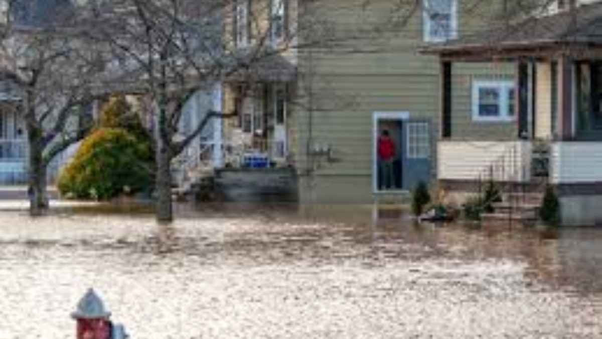
The speed and intensity of rainfall are what make this event particularly dangerous. With rates potentially exceeding two inches per hour, especially in parts of central and western New Jersey, the NWS warns that flash flooding is not just possible but likely.
Officials caution that such heavy rainfall could overwhelm city infrastructure, flooding underground transit, basements, and first floors, and possibly requiring water rescues in areas with poor drainage or rapid runoff.
“A small chance of heavier rain and flooding could pose an elevated threat to life and cause significant disruptions to transportation, flood underground infrastructure and basements and first floors of residences and businesses,” the NWS alert read.
“We’re Preparing for a Serious Storm” — Mayor Eric Adams
New York City officials are treating the situation with utmost seriousness. On July 30, Mayor Eric Adams addressed the public via X (formerly Twitter), saying:
“We’re preparing for a serious storm tomorrow evening.”
The mayor’s office issued travel advisories for both Thursday and Friday, encouraging residents to limit non-essential movement, especially during evening commutes when flooding may become most severe.
“Roads may become flooded during the evening commute,” the city advisory noted.
“Set up flood prevention tools early. If you live in a basement, prepare to move to higher ground.”
“Don’t Trust the Water on Roads” — AccuWeather Warning
AccuWeather meteorologist Alex Sosnowski added a cautionary note about driving in storm conditions, especially at night.
“Roads that appear to only have a small amount of water running across them may be deceiving, especially at night when the visibility is reduced.”
Sosnowski explained that as little as six inches to one foot of moving water can push small vehicles, while SUVs can float in 1 to 2 feet of water. Even without being carried away, vehicles can suffer severe water damage in such scenarios.
State Emergency Services on Alert
Governor Kathy Hochul also weighed in, reminding New Yorkers to stay prepared and vigilant throughout the end of the week.
“As the forecast shifts from extreme heat to heavy rains, I am urging all New Yorkers to stay vigilant and use caution,” Hochul said in a July 30 statement.
“State agencies are on standby for heavy downpours and localized flooding and will be monitoring the situation in real time to ensure the safety of all New Yorkers in the path of the storm.”
In a proactive move, the New York State Division of Homeland Security and Emergency Services encouraged residents to sign up for local emergency alerts by texting their county or borough to 333111.
Where Could the Heaviest Rain Fall?
The final outcome of the flooding threat largely depends on where the frontal boundary stalls. A slight northward shift in the storm system could bring the worst rainfall closer to NYC and surrounding areas. As recent flash flooding events — such as the one in Texas Hill Country — have shown, forecasting rainfall totals to pinpoint accuracy remains a challenge.
As of the latest forecast data, the highest probability of receiving over 4 inches of rain lies just southwest of New York City:
-
Mount Holly, NJ – 34%
-
King of Prussia, PA – 31%
-
West Chester, PA – 24%
-
Trenton, NJ – 22%
-
West Milford, NJ – 10%
For 3+ inches of rain, the probability is even higher:
-
Trenton, NJ – 53%
-
West Chester, PA – 43%
-
Mount Pocono, PA – 34%
-
Doylestown, PA – 33%
-
New York City – 21%
-
Haverstraw, NY – 27%
-
Sherman, CT – 20%
When Will This End?
Relief is in sight. Meteorologists say the worst conditions should taper off by the morning of August 1, with the return of more typical summer weather patterns. Until then, however, flood vigilance remains critical, and residents are advised to take alerts seriously, avoid unnecessary travel, and safeguard their homes and businesses.
With waterlogged streets replacing sun-scorched sidewalks, the tri-state’s weather continues to keep its residents on edge — proving once again that in this region, forecasts can turn dramatically overnight.
As the tri-state region stands between retreating heat and advancing rain, residents must remain alert to nature’s swift unpredictability. With emergency services on standby and alerts in motion, the coming hours demand caution, preparation, and patience. While relief from the scorching temperatures may arrive with the rain, it brings its own dangers in the form of flash floods and travel disruptions. As skies darken and warnings rise, the only certainty is the need to stay informed, stay indoors when possible, and let prudence lead the way through this unfolding storm.
Post a Comment:
In the space provided for comments below, please share your ideas, opinions, and suggestions. We can better understand your interests thanks to your input, which also guarantees that the material we offer will appeal to you. Get in Direct Contact with Us: Please use our “Contact Us” form if you would like to speak with us or if you have any special questions. We are open to questions, collaborations, and, of course, criticism. To fill out our contact form, click this link.
Stay Connected:
Don’t miss out on future updates and articles.